research grant
research grant
-
The Human Factor in Smart Cities: A smart city simulation platform
MSc Thesis by Michal Gath Morad, Advisers: Yehuda E. Kalay, Pnina Plaut
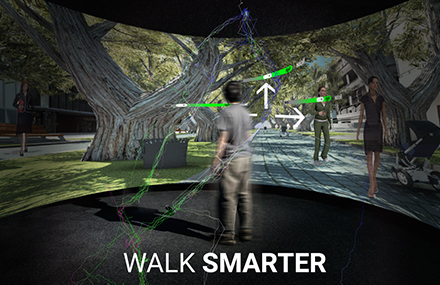 The project is part of a MSc thesis by Michal Gath Morad. The thesis project provides an empirical exploration of “smart cities” from a human, technological and spatial perspective. The main question which underlies the research is how can we tell if Information and Communication Technologies (ICT) could make cities “smarter”? And if yes, what would be the tradeoffs of such urban “smartness”? Unlike past technologies used by cities as part of a strategic plan, carefully devised by planners and experts, today’s most powerful technology —ICT—is used and owned by everyone: planners and citizens alike. A multitude of applications at citizens’ disposal help them process information in real time and empowers them with new decision-making capabilities, which enable them to act according to their individual goals as they gain what I term ”artificial spatial intelligence”. Current research in this field fails to account for the human and spatial factor in “smart cities” and evaluation tools that can help planners evaluate and design truly “smart cities” are limited. To mitigate this gap, a virtual smart city simulation is developed, in which objects (obstacles, people, cyclists, buses, Points of Interest) locations and status is being recorded in real time. The information feed is then processed and delivered to pedestrians, filtered by their personal preferences. To test the effect of this so called “smart city” on pedestrian behavior, the visualisation lab is used to conduct experiments in which real human pedestrians interact with the smart city simulation in a virtual reality setting. The experiment results are still being processed but it’s evident that ICT played a significant role in pedestrian’s decision making process, which in turn transformed the way they walked and “used” the city. The ability to simulate individual pedestrians behavior and how it is affected by enhanced spatial awareness facilitated by ICT, could result in new understanding of how a city is used, making visible less predictable use patterns and contribute to the design of truly smart and livable cities.
-
The use of full-immersion visualization for assessing stakeholder perceptions of cultural ecosystem services in the Carmel Forest.
Dr. Hagit Zimroni, Dr. Daniel Orenstein, Dr. Efrat Eizenberg.
We utilize VizLab to study stakeholder perceptions of landscapes and their associated cultural ecosystem services in Israel’s Carmel Forest. Visualization has become a ubiquitous method in land use planning to actively engage stakeholders in decision making. In our research, funded by the Israel Ministry of Environmental Protection, the subject (stakeholder) is exposed to a diversity of actual and hypothetical landscapes where they can experience and evaluate multiple land use alternatives. We project various high definition photographs reflecting current status of the forest and future scenarios of forest management (e.g. density and species of trees, presence/absence of buffer zones) as a trigger for focused group discussions regarding aesthetic and ecological issues in the forest.
Contact: Dr. Hagit Zimroni.
-
Ecosystem services assessment from the mountain to the sea: A multidisciplinary method for defining ecosystem service indicators across landscape units.
Dr. Michelle Portman, Dr. Daniel Orenstein, Dr. Tally Katz-Gerro (Haifa University), and Mr. Semion Polinov.
We are developing methodologies for identifying, quantifying and analyzing ecosystem services (ES) on land and sea. The case study for our multidisciplinary assessment is a land-sea transect starting on Mt. Carmel and continuing and including the Mediterranean Sea (to the outer limit of Israel’s territorial sea, c. 22 km from the shoreline). Our methodology includes: 1) selection of indicators for valuing ecological, economic and social aspects of ES, 2) developing a GIS-based method for defining the spatial dimensions of ES, and 3) applying the method to policy-making for spatial planning and natural resource management. The Vizlab helps us to perform quality control of services indicators (e.g. visibility of landscape from given geographic points) and to get a better view and understanding of the complexity of the different landscape units as they change spatially and temporally. By using 3D imaging we can improve our understanding about the correlation between visibility from a given point and its aesthetic value as well as view the extent of the transect as a continuous unit from multiple perspective (e.g., flyover view of bathymetry).
Contact: Dr. Michelle Portman.
-
Exploring visibility of urban activity location in virtual reality environment.
Dr. Asya Natapov, Prof. Daniel Czamanski, Dr. Dafna Fisher-Gewirtzman.
This project is part of the PhD research of Asya Natapov. It utilizes VizLab to investigate human navigation in urban environment. In particular, we are interested in the interaction of urban functional structure and human cognitive capabilities, such as vision. We explore the distribution of one particular urban function – cafés, coffee shops, restaurants and other food and drink facilities and investigate their visibility within urban setting of the historical district of Tel Aviv-Yafo, called Lev Hair (City Center). Immersive virtual reality platform of the VizLab allows performing navigational tasks in more controlled way, than in real urban environments. Thus, we construct a three dimensional model of the case study and carry out walk-through experiments in order to investigate human navigational strategies, route choices and decision making processes. During the experiments participants’ trajectories and destination points are tracked. This information is expected to give insights about human perception and navigation in urban space and will be compared with spatial analysis data developed on the previous stages of the research.
Contact: Asya Natapov.
-
Integrated visual analysis and modeling for environmental and urban systems regarding interior space layout and functionality.
Dr. Dafna Fisher-Gewirtzman.
The objective of this research was to develop an integrated analysis and modeling for environmental systems referring to interior space layout and functionality: integrating advanced Spatial Openness Index within realistic geovisualized Geographical Information (GIS) environment and assessment against subjective residents evaluation. In this stage of the research two attempts to develop an elaborated 3D visibility analysis were made. The next step for both models development is considering attributes of the environments, that is to say, the quality of visible space in addition to quantity; establishing an elaborated 3D visibility analysis with a GIS environment. A wide-scale assessment to the voxel based 3D visual analysis have been completed. The results have shown very strong tendency and high correlation between perceived density and the measured volume of space.
Contact: Dafna Fisher-Gewirtzman.
-
Space and Human Perception – Exploring Our Brain’s and Mind’s Reaction to Different Geometries of Spaces.
Graduate student Avishag Shemesh, Dr. Yasha (Jacob) Grobman, Professor Moshe Bar (Bar Ilan University).
This research will aspire to develop and evaluate research methods and tools that examine the connection between geometry of space, visual perception and emotions. Using the Visualization lab in the architecture faculty, which contains 3-D visualization capacity and motion sensors, Participants will be experiencing an inner virtual space, while their brain response and physiological response will be observed. This observation will be possible through the use of advanced handled devices such as EEG and GSR, which will be attached to the participant as he moves freely through the virtual space.
Contact: Avishag Shemesh.